
Guides & videos
Settings — making the app your own
In short: this screen records nothing; it sets up everything else. Three settings deserve five minutes right after installation; you will discover the others as you go.
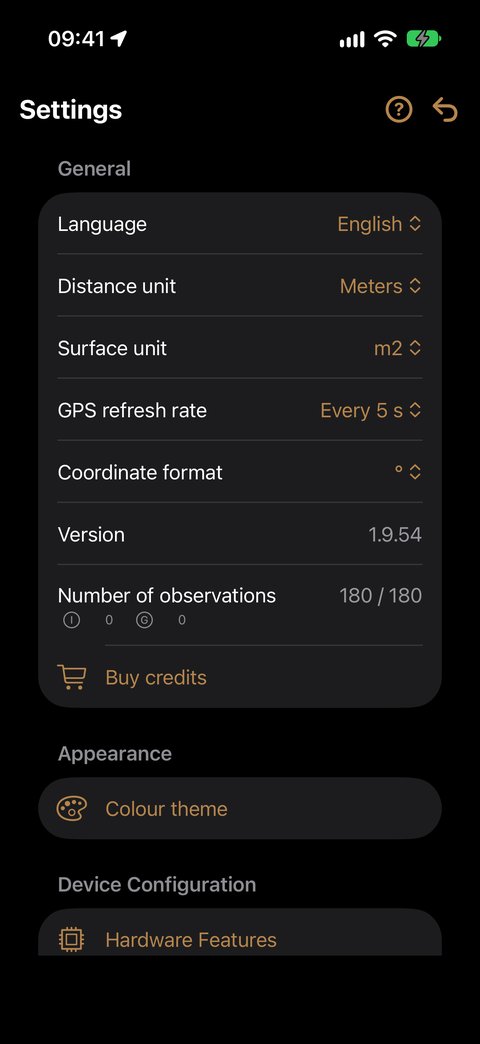
General
| Setting | What it does |
|---|---|
| Language | ten languages available. The app adopts your iPhone's language; change it here if needed. The change is immediate. |
| Distance unit | Meters or Inches. |
| Surface unit | m2 or Hectares. In hectares, areas are displayed the forester's way: 2 ha 34 a 17 ca. |
| GPS refresh rate | from Every 1 s to Every 15 s. More frequent = more responsive, but heavier on the battery. Every 3 s is a good compromise. |
| Coordinate format | decimal degrees, degrees-minutes, degrees-minutes-seconds, or Lambert 93 — the official French system, used by the land register. |
| Version | the installed version, to quote if you report a problem to us. |
| Number of observations | your credit balance, remaining / total, with the breakdown by type of action. |
| Buy credits | to add credits (see below). |
Appearance
Colour theme offers three presentations: iPhone Standard, or the Forest theme in a light (Clearing) or dark (Black Pine) version. The Match iPhone setting switch toggles on its own between Clearing and Black Pine according to your iPhone's light/dark mode; turned off, you force one or the other.
Overlay color sets, in a single choice, everything superimposed on the image: the rotating map and the sight of the compasses, their reticle, and the basal area reticle with the heading and distance shown below it. Choose whatever contrasts best with your terrain.
Device Configuration
Hardware Features
An inventory of what your iPhone can do: camera (with the zoom levels actually available), LiDAR, GPS, compass, microphone.
Each capability has a status:
| Status | What it means |
|---|---|
| 🟢 Active | present and authorized — everything works |
| 🟠 Inactive | present but not authorized — to be unlocked in the iPhone Settings |
| ⚫ Unavailable | not on your model — nothing to do |
This is the screen to open first when a feature does not respond: it tells you whether the problem can be fixed or not.
Relascope Configuration
A wizard guides you through two steps:
- Reference mark — on a vertical surface (wall, door, screen), display a horizontal mark 2 cm wide.
- One-metre distance — stand 1 metre from the mark. The measured distance is displayed live to confirm your position. Then adjust the spacing of the marks (−/+) until they frame the mark exactly, and confirm.
The setting is saved for each zoom level. Five minutes, once.
Observations
Indexing precision — the most important setting in the app.
It is the radius within which a newly created observation is automatically attached to the nearest domain, when you are not inside any drawn parcel.
| Value | Consequence |
|---|---|
| too small | the New observation button stays greyed out outside parcels |
| too large | your observations may be attached to the wrong domain, if two properties are neighbours |
It is 50 m by default, measured from the domain's marker. If your domains are close to one another, keep it short; if you cover large forest blocks without drawn parcels, increase it.
Delete photos without confirmation — if you sort a lot, this option spares you a question at each deletion. Use with care: deleting also removes the photo from your photo library.
Voice input
Delete recordings without confirmation — same logic as above, for voice notes.
Mapping
These settings apply to recording a track.
| Setting | What it does |
|---|---|
| Vibrate on measurement | your iPhone vibrates at each point recorded |
| Play sound on measurement | a sound plays at each point recorded |
| Sound choice | Cheer, Droplet, Note or Bounce |
| Recording interval | 5, 10, 20 or 30 seconds between two points |
Grid
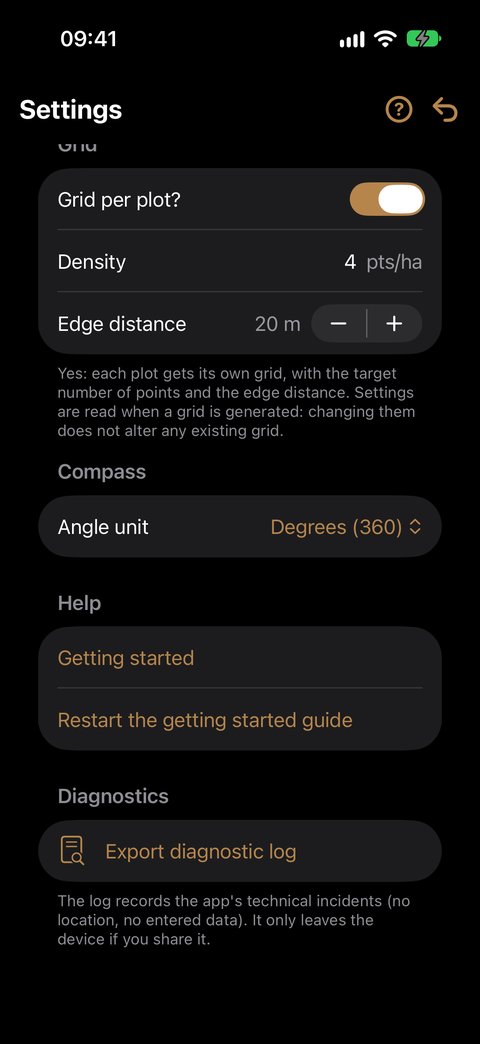
These settings drive the automatic grid of a parcel (see the Mapping guide).
| Setting | What it does |
|---|---|
| Grid per plot? | Yes (default): each parcel gets its own grid. No: a single grid for the whole domain, starting from the domain location, cut by the parcels |
| Density | number of points per hectare (pts/ha), from 0.1 to 50; decimals allowed — 0.5 for one sample plot every 2 ha. 4 by default |
| Edge distance | minimum distance between a point and the parcel boundary, from 0 to 100 m in steps of 5; 20 m by default. Greyed out when Grid per plot? is set to No: it does not apply to the domain grid |
To enter the density, tap the field, type the value, then OK above the keyboard.
Compass
| Setting | What it does |
|---|---|
| Angle unit | degrees (360) or gradians (400) — the surveying and forestry convention |
The overlay colour is set in Appearance (above).
Adding credit
General ▸ Buy credits.
- Open Buy credits: the screen shows your balance and the three packs, priced in your currency.
- Tap a pack, then confirm with Apple (Face ID, Touch ID or password).
- The message "+50 credits. New balance: …" confirms it. Your balance is updated immediately.
Received a code from us? It is used in the App Store, not in the app: tap the link sent with the code. Details: Credits.
Good to know:
- Buying requires a connection. Without network, the screen says so, and your remaining credits still work offline.
- Credits add up and never expire.
- "Purchase awaiting approval": credits are added as soon as the purchase is approved (an Ask to Buy request in Family Sharing, for example).
- Packs, prices and terms: Credits.
When your balance is running low, the notice "Credit almost used up — buy credits" appears below the counter; it opens the purchase screen. At zero, only two actions are suspended (tree, plot): your data remains fully accessible and exportable.
Help
| Setting | What it does |
|---|---|
| Getting started | opens the guided tour, even if it is finished or hidden from the home screen. |
| Restart the getting started guide | resets the tour, after confirmation. The welcome screen and the tips come back the next time the app is launched. Your data is not affected. |
Everything is explained in Getting started and help.
Diagnostics
Export diagnostic log produces a file that records the app's technical incidents — no location, no entered data. It only leaves your iPhone if you share it: attach it to your email if you report a problem to us.
Good to know
- Number fields (density, indexing precision) are closed with the OK button above the keyboard, or by scrolling the screen.
- Every change is immediate: there is no "Apply" button.
- There is no reset to factory settings. Note down your settings before experimenting, in particular the Indexing precision.
- Your settings are included in your exports: the recipient of a backup knows which units you were working in.